What to Expect
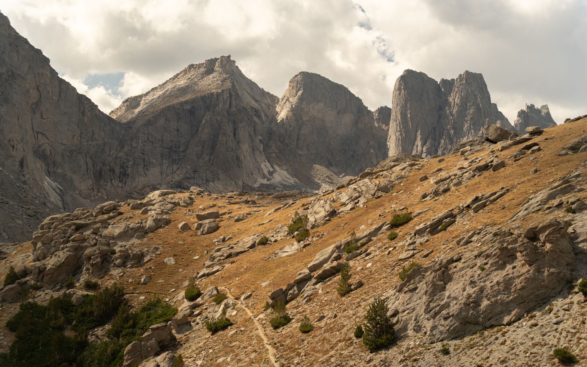
The Wind River Range runs roughly 100 miles along a northwest-to-southeast spine through Fremont County, and the high country starts above 10,000 feet before it gets interesting. More than 40 peaks clear 13,000 feet, with Gannett Peak, the state's highest point at 13,809 feet, sitting near the north end of the crest. The granite here is coarse Archean basement rock shaped into spires and cirques by glaciers that still exist today: Gannett Glacier and Fremont Glacier are among the few remaining glaciers in the American Rockies outside Alaska.
The range is divided into three designated wilderness areas: Bridger Wilderness on the west, Fitzpatrick Wilderness on the east, and Popo Agie Wilderness at the south end. Together they cover roughly 1.4 million acres with no motorized vehicles and no mechanized equipment, which means pack strings, boots, and canoes only. Crowds here are a fraction of what you encounter in Grand Teton two hours north, even in peak July and August.
Three towns serve as the primary bases. Lander anchors the southeast end of the range and runs on climbing culture and outdoor-education programs. Pinedale sits on the southwest side and is the most convenient jump-off for the Bridger Wilderness trailheads. Dubois sits at the north, quieter than the other two, and marks the beginning of the long drive over Togwotee Pass toward Jackson. Each town has gear, food, and fuel, but none has a large grocery store, so plan supplies before you leave the bigger cities. Part of the larger Wind River Country region, these three towns are the practical hubs for everything the range offers.
What to Do There
Backpacking and hiking are the primary draws, and the range has two signature destinations worth planning a trip around. Cirque of the Towers in the Popo Agie Wilderness is a granite amphitheater ringed by Pingora, Warrior, and Watch Tower peaks, reached most directly from the Big Sandy trailhead southwest of Pinedale. The trailhead sits near 9,100 feet elevation, and the standard route to the cirque runs about 9 miles one-way via the Big Sandy Trail. Most backpackers plan 3 to 4 nights to reach the cirque, spend time there, and hike out without crushing the miles. On the Pinedale side, Titcomb Basin via Elkhart Park is equally rewarding: the trailhead at Elkhart Park is 15 miles east of Pinedale on Fremont Lake Road (elevation 9,400 feet), Island Lake is 8.5 miles in, and Titcomb Basin lies another 3 miles beyond that. Plan for talus camping and snowfields possible even in early July.
For day hikers, Sinks Canyon State Park just south of Lander is one of Wyoming's more genuinely unusual natural features: the Middle Fork of the Popo Agie River disappears into a limestone cave and re-emerges in a series of clear pools about a quarter-mile downstream. The hike between the cave and the rise is short and mostly flat. The park also provides trail access to the Popo Agie Wilderness for longer day routes. Before heading into the canyon, gear up at Wild Iris Mountain Sports on Main Street in Lander. The staff track current trail conditions and can set you up with bear canisters, fuel canisters, and any last-minute technical equipment you need.
Rock climbing is serious business here. Wild Iris limestone area, about 25 miles south of Lander on Highway 28, is one of the premier sport-climbing destinations in North America, with hundreds of bolted routes from beginner grades up to 5.14. Sinks Canyon itself has sport and trad routes on its canyon walls. For guided climbing, fishing day trips, or general outdoor guiding in the southern Wind Rivers, Wind River Outdoor Company on Wyoming 789 in Lander is the local outfitter to contact.
At the northwest end of the range, Green River Lakes is reached via a well-maintained gravel road heading north from Pinedale near Cora. The lower lake reflects Squaretop Mountain on calm mornings in a way that draws photographers from across the region, and the first two miles of trail along the lakeshore are accessible to casual walkers. A short detour into Pinedale is worth making for the Museum of the Mountain Man on East Hennick Street, a focused look at the fur-trade rendezvous era that was centered on this corner of Wyoming in the 1820s and 1830s. If you want a comfortable base near the northern Wind Rivers, The Longhorn Ranch Resort Lodge and RV Park on US-26 near Dubois offers lodge rooms, a restaurant, and on-property fly fishing access, about 10 miles from the Torrey Creek trailhead.
Dude ranches are an older tradition in the Wind River foothills on both the east and west sides. For a range of options across the state, including working ranches near the Wind Rivers, the Best Dude Ranches in Wyoming page covers the most-vetted operations with pricing context.
Getting There and Access
From Jackson Hole Airport (JAC), head south on US-191 to Pinedale, about 90 miles, roughly 1 hour 30 minutes of driving. Pinedale is the closest town to the Bridger Wilderness trailheads on the west side of the range. Elkhart Park, the main Pinedale-side access for Titcomb Basin and Island Lake, is 15 miles east of Pinedale on Fremont Lake Road.
From Riverton Regional Airport (RIW), Lander is about 25 miles west on US-26 and Wyoming 789, roughly 30 minutes. RIW is the most practical fly-in option for the south and east trailheads, including Big Sandy and Sinks Canyon. Seasonal service runs from Denver. From Denver International Airport (DEN), the drive to Lander runs about 4.5 to 5 hours via I-25 north to Casper and then US-26 west.
Dubois is about 80 miles east of Jackson over Togwotee Pass on US-26/287. The road over the pass reaches 9,544 feet and can close temporarily in early season snowstorms. The Torrey Creek trailhead for the Fitzpatrick Wilderness is about 10 miles west of Dubois on US-26.
Most trailhead parking areas are gravel and can handle standard vehicles. Big Sandy and Elkhart Park fill on summer weekends. Arriving by 7 a.m. or shifting to a weekday start avoids the parking scramble.
Best Time to Go
July through mid-September is the practical window for the high country. Snow can remain on passes above 11,000 feet through late June, and the Cirque of the Towers is rarely snow-free before early July. Mosquitoes peak in late June and the first two weeks of July just after snowmelt at these elevations, and they can be relentless. Bring a full headnet, not just spray. August is the most reliable month overall: stable weather, minimal bugs, and the longest safe window before early autumn snow.
By late September, temperatures above 10,000 feet drop into the 20s Fahrenheit overnight, and snowstorms can arrive without much warning. Early October is possible on the lower trails around Sinks Canyon and Green River Lakes, but the high cirques are typically done for the season. Trailhead forest roads receive no snow removal in winter, which effectively closes the range from November through May.
Day hiking at Sinks Canyon State Park and along the Green River Lakes shoreline is accessible from late May through mid-October, making the lower elevation destinations a good shoulder-season option.
Good to Know
Wilderness permits for the Bridger, Fitzpatrick, and Popo Agie wilderness areas are free and self-issued at the trailheads as of 2026. There is no timed-entry system or advance quota requirement, which makes last-minute trip planning more feasible than in Yellowstone or Grand Teton. That said, popular trailheads like Elkhart Park and Big Sandy have limited parking, and arriving without a spot means potentially driving out and trying again the next morning.
Grizzly bears are present in the northern Wind Rivers and have expanded their range south in recent years. Carry bear spray on every outing in the range, store food in a bear canister (required in the Bridger Wilderness), and keep your camp clean. Black bears are also present throughout. Packs should not be left unattended at trailheads for multiple days.
Altitude is a real consideration. The Elkhart Park trailhead sits at 9,400 feet; Gannett Peak summit approaches top 13,000 feet. If you fly into Riverton or Jackson from sea level and go straight to the trailhead, symptoms of altitude sickness (headache, fatigue, nausea) on the first day out are common. A rest night at Lander at 5,357 feet or Pinedale at 7,175 feet before ascending helps considerably.
All water sources in the Wind Rivers should be filtered or treated. The range is remote enough that rescue response times are long; a personal locator beacon (PLB) is worth carrying on any multi-day trip into the backcountry.
From Lander, a logical extension of a Wind River Range visit is the thermal terraces at Hot Springs State Park in Thermopolis, about 80 miles north on US-20. The state bath house there is free to use and makes a reasonable post-hike soak on the drive out.
Frequently asked questions
Do I need a permit to backpack in the Wind River Range?
Wilderness permits for the Bridger, Fitzpatrick, and Popo Agie wilderness areas are free and self-issued at the trailheads. There is no advance reservation or quota system as of 2026. The only formal rule is that all food must be stored in a bear canister in the Bridger Wilderness (west side). Check the Shoshone National Forest and Bridger-Teton National Forest websites for any changes to this policy before your trip.
How difficult is the hike to Cirque of the Towers?
The most direct route from the Big Sandy trailhead is about 9 miles one-way with roughly 1,800 feet of elevation gain. The trailhead itself starts near 9,100 feet, so the effort isn't extreme in terms of vertical, but the thin air at elevation and the talus terrain near the cirque add to the physical challenge. Most backpackers rate it moderate to strenuous. Plan at least 2 to 3 days for the roundtrip if you want time to explore inside the cirque rather than just passing through.
Are grizzly bears present in the Wind River Range?
Yes. Grizzly bears have an established and expanding presence in the northern Wind Rivers, particularly in the Fitzpatrick Wilderness and the Dubois area, and have been documented farther south in recent years. Carry bear spray and know how to use it on every outing in the range. Store all food, scented items, and trash in a bear canister or hang at least 10 feet off the ground and 4 feet from the trunk. Do not leave food in vehicles at trailheads.
What is the nearest airport to the Wind River Range?
Riverton Regional Airport (RIW) is the closest option, about 25 miles from Lander and the south-side trailheads. Seasonal service connects Riverton to Denver. Jackson Hole Airport (JAC) is about 90 miles from Pinedale and serves more carriers with more daily flights, making it the most practical choice for the west-side trailheads. Denver International Airport (DEN) is about 4.5 to 5 hours by car and is the most common fly-in hub for visitors coming from the east or south.
When do mosquitoes die down in the Wind Rivers?
Mosquitoes are most intense from late June through the first two weeks of July, immediately after snowmelt at the upper elevations. By early August they typically drop to manageable levels. If you're camping in the first half of July, a headnet is not optional. Full-coverage clothing and DEET-based repellent help, but a headnet is the single most effective tool for the peak bug window.