How We Picked
These seven drives were chosen because they deliver consistent visual impact, cover distinct corners of Wyoming, and are realistic for a visitor with a standard rental car and a free afternoon or full day. Every drive on this list has a clear seasonal window (noted below), a named starting town with fuel and food, and a payoff that goes beyond a generic high-altitude overlook. Routes were weeded out if they required high-clearance or four-wheel drive, or if the payoff was modest relative to driving time. The Wyoming Travel Guide covers all six regions these drives pass through. For the northwest corner, the Jackson Hole and the Tetons overview is the best companion to the two Teton-area drives on this list.
1. Chief Joseph Scenic Byway (WY-296)
The Chief Joseph Scenic Byway runs 46 miles from the WY-120/US-212 junction northeast of Cody north to Cooke City, Montana, climbing into the Absaroka Range and dropping into the Sunlight Basin. The road reaches 8,060 feet at Dead Indian Summit before descending through switchbacks above the Clarks Fork of the Yellowstone River, a canyon so steep in places the water disappears from view entirely below you. This is the least-traveled of Wyoming's major byways and earns it: you can drive the full 46 miles on a summer weekday and count the oncoming cars on two hands.
The Chief Joseph junction is about 17 miles northeast of Cody on US-212. The byway is generally open May through October; early May can still see snow at the summit. Pair it with the Beartooth Highway back through Red Lodge and down into Cooke City for a full-loop day drive that covers two of the best mountain roads in the Lower 48. Book a room in Cody the night before. Buffalo Bill's Irma Hotel and Restaurant, the 1902 property on Sheridan Avenue that Buffalo Bill built himself, makes a good base, and a morning at the Buffalo Bill Center of the West fills the time before the afternoon drive.
2. North Fork Highway / Buffalo Bill Scenic Byway (US-14 Alt)
This 52-mile corridor between Cody and Yellowstone's East Entrance follows the North Fork of the Shoshone River through a canyon of volcanic tuff and welded ash formations before opening onto the high plateau approaching the park. Theodore Roosevelt reportedly called the first miles west of Cody the most scenic 50 miles in the United States. The canyon walls run from orange to burgundy and have eroded into formations that earned individual names over the decades: the Holy City, the Palisades, the Chinese Wall. Grizzlies work the sagebrush benches above the river in spring and fall, and bison are regularly seen between the canyon mouth and the East Entrance.
The East Entrance brings you into Yellowstone at Sylvan Pass, elevation 8,530 feet, bypassing the summer backups at West Thumb and the South Entrance. Driving time from Cody to the East Entrance gate is about one hour. Fuel in Cody before you leave. For what to do with an evening in Cody before or after the drive, the Best Rodeos in Wyoming page covers the Cody Nite Rodeo, which runs every evening June through August.
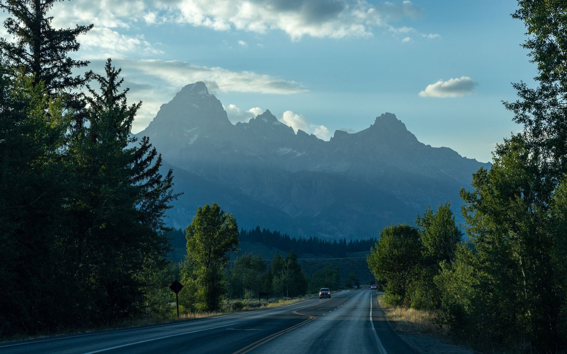
3. Teton Park Road (Grand Teton National Park)
The 42-mile Teton Park Road runs along the base of the Teton Range inside Grand Teton National Park, from Moose Junction north to Jackson Lake Junction. It parallels the main US-26/89/191 highway but places you two to three miles closer to the range, with peaks topping 12,000 feet filling the windshield. Pull-outs at Schwabacher Landing, the Oxbow Bend, Signal Mountain Summit Road, and String Lake give you wildlife viewing and photography stops without adding much time. Moose, pronghorn, osprey, and bald eagles are regulars along this stretch through summer. The road opens to cars in late May and closes around early November depending on conditions; the southern section near Moose stays accessible year-round for non-motorized use.
Jackson is about 12 miles south of Moose Junction via US-89. Cowboy Village Resort on Flat Creek Drive in Jackson offers cabin-style rooms at mid-range prices for the area (estimate $200 to $350 per night in summer), and you can reach the Moose Visitor Center in under 20 minutes from there. Flying into Jackson Hole Airport (JAC), which sits inside the national park boundary, puts you within 15 minutes of the southern Teton Park Road entrance. The full Jackson Hole and the Tetons guide covers every access point and gate.
4. Bighorn Scenic Byway (US-14 and US-14A)
The Bighorn Scenic Byway crosses the Bighorn Mountains between Lovell and Sheridan via two distinct routes that together form a 130-mile loop worth driving as a complete circuit rather than picking one side. US-14A to the north climbs to the Medicine Wheel National Historic Landmark at 9,642 feet, a 75-foot-diameter stone wheel used by Northern Plains peoples for centuries with views across the Bighorn Basin to the Beartooths on a clear day. US-14 to the south descends through Shell Canyon, where the road drops 2,500 feet in under 10 miles and limestone walls rise 1,000 feet on both sides with Shell Creek cutting through the canyon floor.
Cloud Peak, the Bighorn range high point at 13,175 feet, is visible from several overlooks on US-14. Both routes are typically open late May through October; the high sections close in winter and can hold snow well into May. Services thin out quickly once you leave Lovell or Shell, so fill up before the climb. Sheridan, at the east end of both routes, has a working Main Street worth a stop. See the Best State Parks in Wyoming page for details on Amsden Creek Wildlife Habitat Management Area and Connor Battlefield State Historic Site, both within 30 miles of Sheridan.
5. Snowy Range Scenic Byway (WY-130)
WY-130 climbs from Laramie at 7,200 feet through Medicine Bow National Forest to a 10,847-foot summit before dropping to Saratoga in the North Platte River valley. The 67-mile route crosses alpine tundra above treeline, passes granite lakes that hold ice into July, and reaches the trailhead for Medicine Bow Peak at mile 28, a 5-mile round-trip hike that tops out at 12,013 feet with views back toward Laramie and the Colorado Rockies on the south horizon. The pass closes from roughly mid-November through Memorial Day weekend depending on snowpack; check the Wyoming Department of Transportation site at wyoroad.info before planning any late-season drive.
Laramie is the natural base. J's Prairie Rose Cafe on South 2nd Street in Laramie is a local institution for breakfast before the drive, known for large portions and genuinely good green chile. The drive from Laramie to Saratoga takes about 90 minutes at a reasonable pace with a few stops. Saratoga itself has the free Saratoga Hot Pool on the North Platte riverbank for an outdoor soak at the end of the day, no charge to enter.
6. Wind River Canyon (US-20)
Wind River Canyon is the shortest drive on this list and among the most geologically striking anywhere in the state. US-20 threads through a 10-mile canyon between Thermopolis and Shoshoni where the Wind River has cut through Precambrian granite 2.9 billion years old, some of the oldest exposed rock in North America. The walls rise 1,400 to 2,500 feet off the canyon floor, and the road competes for space with the Burlington Northern Santa Fe rail line the entire length. Geological markers placed along the pullouts label each visible rock formation by period, running from youngest near Thermopolis to oldest as you drive south toward Shoshoni.
Thermopolis anchors the north end with Hot Springs State Park, where the State Bath House offers free mineral soaks and the spring itself is one of the largest in the world. Wind River Canyon is one of the few drives on this list that is open and worth doing year-round. Allow 30 to 40 minutes to drive it at a comfortable pace with one or two stops. The Best State Parks in Wyoming guide has full detail on Hot Springs State Park and the Wyoming Dinosaur Center across town.
7. South Entrance Corridor (US-89/191) through Grand Teton
The 57-mile stretch of US-89/191 from Jackson north through Grand Teton National Park to Yellowstone's South Entrance is the most heavily traveled scenic corridor in Wyoming, and the crowds tell you something. The Snake River Overlook where Ansel Adams made his 1942 photograph of the Tetons is a genuine landmark, not a tourist fabrication. Mormon Row barns near Moose are some of the most photographed structures in the West. Willow Flats near Jackson Lake Lodge draws moose almost every morning in summer. The Oxbow Bend east of Jackson Lake Junction offers one of the most reliable bird and wildlife viewing spots in the entire park system.
This corridor also sees the most bison jams in Wyoming: bison cross the road between May and October regularly enough that you should budget extra time and keep your distance from animals on the shoulder. Traffic through the Tetons in July and August can slow to a walking pace at popular pull-outs; starting before 8 a.m. or driving after 5 p.m. makes a real difference. For lodging options across the full valley, the Hotels and Lodges directory includes properties from budget to high-end within 30 minutes of the park's south boundary.
Quick Comparison
| Drive | Length | Open Season | Nearest Town | Best For |
|---|---|---|---|---|
| Chief Joseph Scenic Byway (WY-296) | 46 mi | May–Oct | Cody | Solitude, Sunlight Basin, Clarks Fork canyon |
| North Fork / Buffalo Bill Scenic Byway (US-14 Alt) | 52 mi | Year-round | Cody | Volcanic formations, wildlife, Yellowstone access |
| Teton Park Road | 42 mi | Late May–Nov | Jackson | Close-up Teton views, low traffic vs. main highway |
| Bighorn Scenic Byway (US-14 / US-14A loop) | 130 mi loop | Late May–Oct | Sheridan or Lovell | Shell Canyon, Medicine Wheel, Cloud Peak views |
| Snowy Range Scenic Byway (WY-130) | 67 mi | Jun–mid-Nov | Laramie | Alpine tundra, granite lakes, Saratoga hot springs |
| Wind River Canyon (US-20) | 10 mi | Year-round | Thermopolis | Ancient geology, sheer canyon walls, short time commitment |
| South Entrance Corridor (US-89/191) | 57 mi | Year-round | Jackson | Snake River Overlook, bison corridor, Teton views |
Frequently asked questions
What is the most scenic drive in Wyoming?
The Chief Joseph Scenic Byway (WY-296) and the North Fork Highway (US-14 Alt) are the two strongest drives in the state, both based out of Cody and both running toward Yellowstone country. The Chief Joseph covers 46 miles of Sunlight Basin and the Clarks Fork canyon with almost no traffic. The North Fork follows 52 miles of volcanic canyon between Cody and Yellowstone's East Entrance. Combine them into a loop through Cooke City via the Beartooth Highway and you have a full-day drive covering some of the most dramatic terrain in the American West. If you want the single most crowd-free experience, the Chief Joseph wins. If you want to end the day inside Yellowstone, drive the North Fork.
Which Wyoming scenic drives are open year-round?
Wind River Canyon on US-20 between Thermopolis and Shoshoni is open year-round and is worth doing in any month. The South Entrance Corridor (US-89/191) through Grand Teton National Park stays open year-round, though the inner Teton Park Road closes to cars from around early November to late May. The North Fork Highway between Cody and Yellowstone's East Entrance is generally drivable outside of heavy snowstorms, though the Yellowstone East Entrance itself closes from early November to late April. The Snowy Range Scenic Byway (WY-130), Bighorn Scenic Byway, and Chief Joseph Scenic Byway all close at their high-elevation sections in winter. Check wyoroad.info for current road status before driving any mountain pass from October through May.
Do I need a national park pass to drive these routes?
Yes, for two of them. The Teton Park Road and the South Entrance Corridor (US-89/191) both pass through Grand Teton National Park, which charges a vehicle entry fee of $35 for a 7-day pass (check nps.gov for the current price). The America the Beautiful annual pass at $80 covers both Grand Teton and Yellowstone and pays for itself on most Wyoming trips. The Chief Joseph Scenic Byway, North Fork Highway, Bighorn Scenic Byway, Snowy Range Scenic Byway, and Wind River Canyon are all free to drive and do not require a park entry fee.
How far apart are Wyoming's scenic drives, and can I do more than one in a day?
Wyoming is large and drives are far apart: Jackson to Cody is about 2.5 hours via US-26/287 or longer if you route through Yellowstone. Cody to Sheridan is around 2 hours on US-14/16. Laramie to Thermopolis is about 3 hours via US-30 and US-20. Combining drives from different regions in a single day is not realistic unless you accept that you will rush through both. The most logical single-day pairings are: Chief Joseph Scenic Byway plus the Beartooth Highway loop from Cody (about 8 to 10 hours of driving and stopping); Teton Park Road plus the South Entrance Corridor from Jackson as a north-south loop (about 3 to 4 hours with stops); or Bighorn Scenic Byway as a full loop from Sheridan (about 5 to 6 hours).