What to Expect
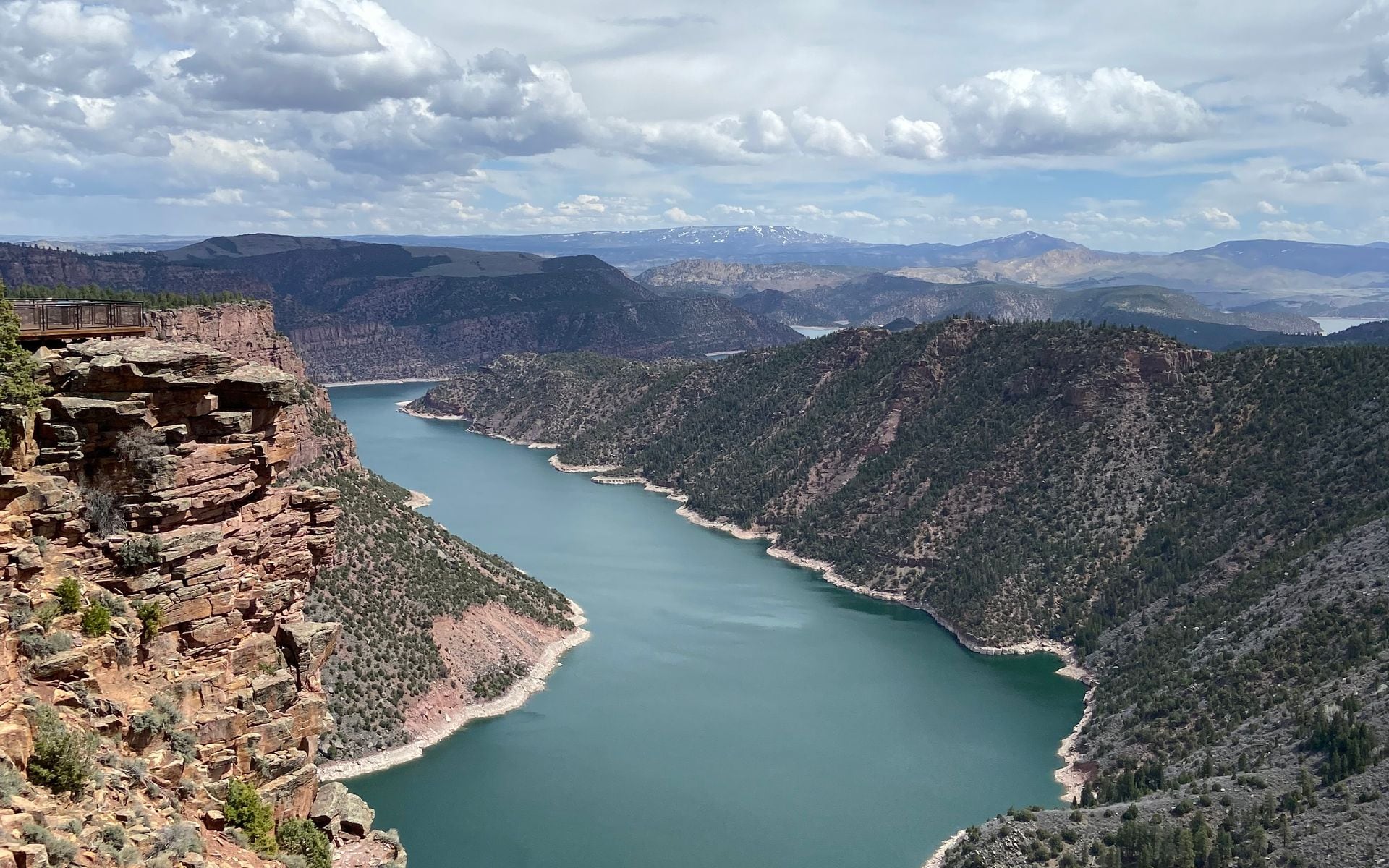
Flaming Gorge takes its name from John Wesley Powell, who floated the Green River in 1869 and logged these canyon walls as a river of flame. The color holds up. The upper sections of the reservoir, on the Wyoming side, pass through layered red and orange Uinta formation sandstone that turns deep rust in the afternoon light. The Bureau of Reclamation finished Flaming Gorge Dam in 1964, impounding the Green River to create one of the larger reservoirs in the Intermountain West. The Wyoming portion covers the northern end of the lake, accessed from Green River and Rock Springs via US-191, and includes some of the least-crowded camping and shoreline access anywhere in Southwest Wyoming. The Utah side, closer to the dam, draws heavier summer boat traffic and holds the main marina infrastructure near Dutch John.
This is not a park with a visitor center at the main gate and a ranger-led walk at 10am. Flaming Gorge is wide, flat-rimmed high desert around a long blue lake, and the experience is largely self-directed: you pick a campground, launch a boat, or pull off on the Sheep Creek Geological Loop and work out what you're looking at. The reservoir sits at about 6,040 feet in elevation, which keeps summer temperatures cooler than you'd expect from the desert setting, but the Wyoming side can be windy. Afternoons build up fast. The canyon is still and dramatic early in the morning, rougher by 2pm. Plan accordingly, especially on the water.
What to Do There
The primary draw for serious anglers is a two-part fishery: trophy lake trout in the reservoir itself, and a tailwater fishery on the Green River running about seven miles below the dam. The lake holds mackinaw that regularly run 20 to 40 pounds, with fish over 50 pounds documented. Trolling deep with tube jigs in 80 to 120 feet of water is the standard approach in summer; spring (April and May) and fall (October and November) push lake trout shallower and make for the most productive surface-area fishing. The Green River tailwater below the dam is managed as a blue-ribbon trout fishery and produces large brown trout and rainbows year-round. For guided float trips on the tailwater, fly fishing operations based in Dutch John, UT handle most of the traffic. Western Rivers Flyfisher Guides and Shuttle Service, headquartered at Dutch John, has been putting clients on fish in this stretch for years and earns consistently strong reviews. A guided float runs roughly $450 to $650 per boat depending on season and group size (labeled estimate). If you want to fish on your own, the river road below the dam provides wade access at multiple pull-offs. For more context on how this river stacks up against other fisheries across the state, see the rundown of Best Fly Fishing Rivers in Wyoming.
Beyond fishing, the Sheep Creek Geological Loop on the Wyoming side is one of the most underappreciated drives in the state. The 13-mile gravel byway cuts through rock layers that span 300 million years of geological history, from Uinta Mountain quartzite to Cretaceous shale. Interpretive signs label the formations, which makes it unusually educational for a back-road loop. Budget about an hour and a half for a leisurely drive with stops. Firehole Canyon Campground on the Wyoming side of the reservoir is a good base: sites sit right above the water and the boat ramp is easy to use. Antelope Flat Campground, also on the Wyoming side, gives you more space and is better suited to larger rigs. Boating, kayaking, and wakeboarding are all permitted on the main reservoir, and the flat red-rock shoreline makes for good walking in the early morning before the wind picks up.
Getting There and Access
The main Wyoming approach is US-191 south from Rock Springs, about 40 miles to the Wyoming-Utah state line and another 15 miles to Dutch John and the dam. From Green River, WY, it's a similar drive of around 50 miles on the same highway. Rock Springs Regional Airport (RKS) is the closest commercial airport, with service to Denver (DEN) and Salt Lake City (SLC). Most travelers fly into SLC and drive north on I-15 to I-80 and then south on US-191, a route of about 2.5 to 3 hours depending on your destination within the gorge area. Travelers coming from the north on I-80 often overnight in Evanston, about 90 miles northwest of the gorge via US-189; Best Western Dunmar Inn in Evanston is a practical stop with an indoor pool and on-site dining at the Legal Tender restaurant. If you're coming from Jackson Hole (JAC), plan on 3.5 to 4 hours south via US-189 through Pinedale. Cell service is limited on US-191 south of Rock Springs. Download your maps before you leave town. The Wyoming side of the reservoir has no fuel or groceries, so stock up in Rock Springs or Green River before you head south.
Best Time to Go
Summer (June through August) is peak season for boating and camping. Reservoir temperatures warm enough for swimming by late June, campgrounds fill on weekends, and the lake sees the most boat traffic. If you're here to fish the lake, spring is the better window. Lake trout move shallow in April and May before retreating deep as water temperatures rise, and May into early June also sees some of the best tailwater fishing before runoff clarifies the river. Fall brings the shoulder season: campgrounds thin out after Labor Day, the tailwater fishes well through October, and the canyon walls shift colors slightly as the red sandstone catches lower-angle October sun. Winter access is limited but possible on the Wyoming side; most campground facilities close from October through April, and US-191 can be icy and snow-covered from November onward. Spring is typically the worst combination of mud, icy mornings, and variable road conditions.
Good to Know
Flaming Gorge sits in two states, and the licensing situation catches people off guard. The Wyoming-Utah line runs roughly through the upper reservoir, and the dam and tailwater fishery below it are in Utah. If you're camping and fishing on the Wyoming side of the reservoir, a Wyoming fishing license covers you. Once you cross into Utah, including the tailwater below the dam, you need a Utah fishing license. Both licenses are available online or at sporting goods stores. If you're making a day trip from the Pinedale area with a stop in Green River, Great Outdoor Shop in Pinedale (on Pine Street) stocks Wyoming licenses along with flies, leaders, and local knowledge about conditions on the upper Green River before it hits the reservoir. Day use at the reservoir is managed by the Ashley National Forest on the Utah side and the Bridger-Teton National Forest on the Wyoming side, with camping fees typically running $15 to $25 per night at developed sites (labeled estimate).
Frequently asked questions
Is Flaming Gorge in Wyoming or Utah?
Both states. The reservoir spans 91 miles across the Wyoming-Utah state line, with the northern section of the lake lying in Wyoming and the dam, Dutch John, and the Green River tailwater fishery located in Utah. Most of the visitor infrastructure, including the main marina and the dam visitor center, sits on the Utah side, but the Wyoming portion includes quieter campgrounds like Firehole and Antelope Flat and the Sheep Creek Geological Loop.
What fish can you catch at Flaming Gorge?
The reservoir holds trophy lake trout (mackinaw), smallmouth bass, and kokanee salmon. Lake trout are the signature catch, with fish running 20 to 40 pounds commonly and documented fish over 50 pounds. The Green River tailwater below the dam below Dutch John is managed as a blue-ribbon fishery with large brown trout and rainbow trout. Stricter catch limits apply to maintain trophy fish quality, so check current Utah and Wyoming regulations before you go.
Do I need a Utah fishing license to fish at Flaming Gorge?
It depends where you're fishing. If you're on the Wyoming side of the reservoir, a Wyoming license covers you. The tailwater below Flaming Gorge Dam and the southern section of the reservoir are in Utah and require a Utah license. Many anglers visiting from Wyoming pick up both licenses before the trip, since guided float trips on the tailwater out of Dutch John operate entirely in Utah.
How do you get to Flaming Gorge from Rock Springs?
Take US-191 south from Rock Springs. It's about 40 miles to the Wyoming state line and another 15 miles or so to Dutch John and the dam. The drive takes under an hour in good weather. Stock up on fuel and groceries in Rock Springs before you go, since there are no services on the Wyoming side of the reservoir.