How We Picked
We evaluated rivers across Wyoming on consistent trout populations, reliable public access or established guide services, fishable season length, and geographic spread across the state. A river made this list if it produces trout regularly for visiting anglers of average skill and has clear, documented access points that don't require a guide to find. The rivers here range from national park water inside Yellowstone to tailwater fisheries within an hour of I-80. For broader planning context when organizing a trip around one of these rivers, the Wyoming Travel Guide covers all six regions of the state, including where to base and how to move between them.
North Platte River: Grey Reef and the Miracle Mile
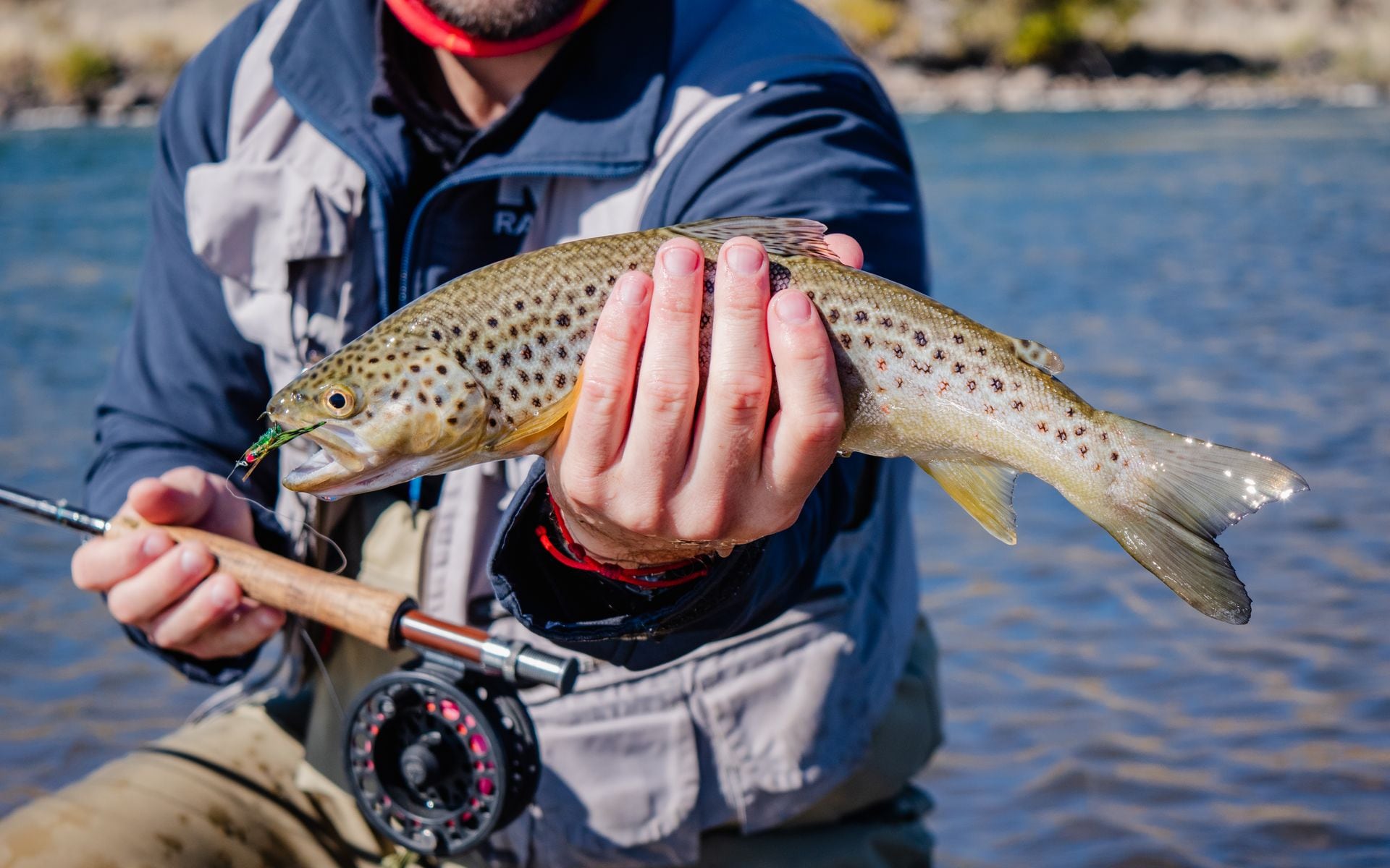
The North Platte below Pathfinder Reservoir is where serious Wyoming fly anglers spend most of their time, and the numbers back that up. The Grey Reef section runs roughly 8 miles of catch-and-release regulated water south of Alcova, about 30 miles south of Casper on Wyoming Highway 220. Cold, clear tailwater from Pathfinder Dam keeps the river running at ideal trout temperatures even through July, and the Grey Reef section holds rainbows averaging 16 to 20 inches, with larger fish caught regularly on midges and baetis patterns. October through April is the peak window for the biggest fish, when water clarity is high and crowd pressure drops sharply. Guided float trips on Grey Reef typically run $500 to $700 per day for two anglers with gear included (labeled estimate). Wyoming Anglers, based in Casper at 5625 CY Ave., holds consistently top-rated guides on this stretch and books the Grey Reef section heavily from October onward. Cowboy Drifters also runs guided floats out of Casper on both Grey Reef and adjacent North Platte water and is known for multi-day lodge packages with riverside cabin accommodations.
About 5 miles below Kortes Dam, between Pathfinder and Seminoe reservoirs along Wyoming Highway 287, the Miracle Mile offers a more open stretch of the North Platte with good wade access from multiple highway pullouts. Brown trout run large here alongside rainbows, and the fishing pressure, while present, is lower than Grey Reef on most days. Wyoming Fly Fishing Guide Service operates on this stretch and is one of the more established North Platte outfitters working out of the Casper area.
Snake River
The Snake River through the Jackson Hole and Tetons region is Wyoming's most visible fly fishing corridor, and it earns that standing on the water. The river holds native westslope cutthroat trout from the dam at Jackson Lake south through Grand Teton National Park and into the canyon below. Float trips typically launch from South Park Bridge, 8 miles south of the Jackson town square on US-26/89, and cover 10 to 14 miles downstream depending on the day's plan. A half-day guided float runs roughly $350 to $500 per person (labeled estimate), with full-day rates running higher. The best cutthroat action runs June through late September, with fish most active in mid-July once snowmelt clears and river levels settle. Teton Floats, based in Jackson at 165 N. Glenwood Street, runs well-regarded guided fishing and scenic float trips with guides who know the cutthroat holding water from seasons on the river, not guesswork. Fly into Jackson Hole Airport (JAC), located inside Grand Teton National Park, and you can be on the water the same afternoon. The Snake also flows directly through the park, making it straightforward to pair a fishing day with a drive on the Teton Park Road, covered on our Best Scenic Drives in Wyoming page.
Green River
The Green River below Flaming Gorge Dam produces some of Wyoming's largest brown trout in a 14-mile tailwater stretch where dam-controlled releases hold water temperatures cold and consistent year-round. The most productive water starts immediately below the dam and runs south into Utah through red sandstone canyon. Wyoming anglers typically base in Rock Springs (about 90 miles west of the dam on I-80) or in Pinedale (roughly 90 miles north on US-191) and drive south. Browns running well above 20 inches come up reliably in this fishery, alongside large rainbows. Because flows are dam-regulated, this water stays productive even in drought years when freestone rivers across central Wyoming drop out. Wyoming Fishing Company, based near Daniel on US-189 in Sublette County, runs guided drift trips covering the upper Green River drainage and connects clients to the Flaming Gorge tailwater. Guided float trips on this water run approximately $500 to $650 per day for two anglers (labeled estimate). For lodging options in the Pinedale or Rock Springs area to use as a base, our Hotels and Lodges directory covers the region.
Wind River
The Wind River cuts through a 2,500-foot canyon between Thermopolis and Shoshoni, a 35-mile stretch with canyon walls exposing sedimentary and Precambrian rock layers dating back 2.7 billion years, some of the oldest exposed geology in North America. Brown trout and rainbow hold throughout this canyon water with public access from multiple pullouts along US-20. Spring runoff typically clears by late June and the river fishes well from July through October, with fall being the most reliable period for larger browns feeding aggressively before winter. Wind River Canyon Whitewater and Fly Fishing, based at 731 Shoshoni Street in Thermopolis, guides half-day and full-day fishing and scenic float trips through the canyon. Pairing a morning on the river with an afternoon at Hot Springs State Park in Thermopolis, where you can soak in one of the largest mineral hot springs in the world at no charge, makes Thermopolis one of the more efficient single-day itineraries in central Wyoming.
Shoshone River: North Fork
The North Fork of the Shoshone runs from the East Entrance of Yellowstone through canyon country above Cody, following US-14/16/20 for roughly 52 miles along the North Fork National Scenic Byway. Wild brown trout and cutthroat hold throughout the pocket water in the upper canyon, and access is straightforward: pullouts line the highway at regular intervals for the full length of the fishable stretch. The fish run smaller than what you'll find on the regulated North Platte, typically 10 to 15 inches, but the setting compensates. Steep volcanic canyon walls, lodgepole pine hillsides, and in September, elk on the surrounding slopes make this one of the more atmospheric wade fishing corridors in the state. Late June through July offers the best dry fly action after snowmelt stabilizes, and the river holds well through October. Several Cody-area outfitters guide both the North Fork and the South Fork of the Shoshone for anglers who want local expertise on these less-documented waters. The road itself is one of the more dramatic approaches to Yellowstone and is covered in more detail on our guide to Wyoming scenic drives.
Clark's Fork of the Yellowstone
The Clark's Fork drains the northeast corner of Wyoming between the Beartooth Plateau and the canyon near Crandall, about 60 miles northeast of Cody on Wyoming Highway 296. It is a freestone river with no dams and no tailwater temperature buffer, which means wild cutthroat trout that see far fewer anglers than the Snake River or the waters inside the park. The canyon section below Sunlight Basin holds deep pools and broken pocket water, and reaching the best spots requires some scrambling on uneven terrain. July and August are the most reliable months after snowmelt clears, with September bringing reliable dry fly action and aspen color on the surrounding hillsides. Plan for a self-guided wade trip on this one: no major guide operations are based specifically on the Clark's Fork, so a topo map and a high-clearance vehicle for the forest road access points off WY-296 are worth having before you head out.
Firehole River (Yellowstone National Park)
The Firehole is one of the genuinely unusual fly fishing rivers in the country. Thermal runoff from geyser basins along its banks keeps the river from freezing in winter but also pushes water temperatures into the upper 70s Fahrenheit during mid-July through mid-August, which is too warm for trout to feed reliably. The productive window runs late August through October, when temperatures drop back into range and brown trout move into pre-spawn feeding patterns before the season closes. The river flows through the Madison Junction area of Yellowstone, reachable in roughly 45 minutes from the West Entrance near West Yellowstone, Montana. Dry flies work well in fall, particularly elk hair caddis and blue-winged olive patterns in size 16 to 18. Fishing inside Yellowstone requires a park fishing permit rather than a Wyoming state license. The park permit runs approximately $18 per day or $40 for a season permit (labeled estimate). Check current park regulations before going, as some sections of the Firehole carry species-specific restrictions that change year to year.
Quick Comparison
| River | Primary Species | Best Season | Float or Wade | Nearest City |
|---|---|---|---|---|
| N. Platte: Grey Reef | Rainbow, Brown | Oct–Apr | Float and wade | Casper |
| N. Platte: Miracle Mile | Brown, Rainbow | May–Oct | Wade | Casper |
| Snake River | Cutthroat, Brown | Jun–Sep | Float | Jackson |
| Green River | Brown, Rainbow | Year-round | Float | Rock Springs / Pinedale |
| Wind River | Brown, Rainbow | Jul–Oct | Float and wade | Thermopolis |
| Shoshone (N. Fork) | Brown, Cutthroat | Jun–Oct | Wade | Cody |
| Clark's Fork | Cutthroat | Jul–Sep | Wade | Cody |
| Firehole (in-park) | Brown, Rainbow | Late Aug–Oct | Wade | West Yellowstone, MT |
Frequently asked questions
Do I need a Wyoming fishing license to fly fish in Yellowstone National Park?
No. Fishing inside Yellowstone National Park requires a Yellowstone park fishing permit rather than a Wyoming state license. The park permit runs approximately $18 per day or $40 for a season permit (labeled estimates; verify current fees at the NPS website before your trip). Wyoming fishing licenses are required for all waters outside the park, including the Snake River below Jackson Lake Dam, the North Platte, the Green River, the Wind River, and the Shoshone. Non-resident Wyoming licenses run approximately $14 per day for short-term use or around $92 for a full-season license (labeled estimates; verify with Wyoming Game and Fish before purchasing).
What time of year is best for fly fishing in Wyoming?
It depends on the river. June through September covers the broadest productive window across most of the state. The Snake River cutthroat are most active mid-July through mid-September once snowmelt-driven flows settle. The North Platte's Grey Reef section peaks from October through April, when large rainbows feed actively on midges in clear, cold tailwater. The Firehole inside Yellowstone is best late August through October, after thermal-influenced summer water temperatures drop back into a safe range for feeding trout. Freestone rivers like the Clark's Fork and the upper Shoshone open up after snowmelt clears, typically late June, and fish well through September. Spring runoff can muddy freestone water from late April through mid-June.
What do guided fly fishing trips cost in Wyoming?
Most outfitters charge $500 to $700 per day for a guided drift boat trip with two anglers, including rods, reels, flies, and lunch (labeled estimates). Half-day wading guide trips run approximately $300 to $450 per person (labeled estimate). Rates in the Jackson Hole area tend to run 15 to 20 percent higher than those in the Casper area for comparable guided float trips. Booking three to six months in advance is standard for peak-season dates, particularly October through December on the Grey Reef section of the North Platte and July through August on the Snake River.