How We Picked These Trails
We chose hikes that return scenery specific to Wyoming: Teton peaks, Yellowstone thermal basins, Wind River granite, a 867-foot volcanic column, and canyon geology you won't find anywhere else. Each trail on this list is maintained and signed, accessible to visitors without technical climbing gear, and spans a range of distances from a 1.3-mile flat loop to a 26-mile backpacking route. For broader planning context across the state, the Wyoming Travel Guide covers all six regions. Wildlife shares most of these corridors, and many of the same areas appear on our guide to the Best Places to See Wildlife in Wyoming, so moose, bears, bison, and bighorn sheep factor into your planning on multiple hikes here.
Opening dates depend on the year's snowpack and can shift by two to three weeks in either direction. All dates listed are typical ranges. Check current conditions with the NPS or Wyoming State Parks before you make a long drive to a trailhead, particularly in May and June.
Cascade Canyon Trail, Grand Teton National Park
Distance: 9 miles round-trip. Elevation gain: 1,000 feet. Difficulty: Moderate. Season: June through October. The most-used trail in Grand Teton starts at the south shore of Jenny Lake, 20 minutes north of Jackson on the Teton Park Road. Take the shuttle boat to the west dock (about $20 per person each way, estimate) and you cut 2 miles off the round-trip distance, skipping the flat lakeside trail and reaching the canyon section faster. From the west dock the route follows Cascade Creek into a U-shaped glacial canyon flanked by Mount Owen and Teewinot Mountain. At mile 4.5 the trail forks north toward Lake Solitude and south toward Death Canyon. Most day hikers turn around here. The canyon itself is the reward, not the fork. Jenny Lake parking fills by mid-morning in July and August, so starting before 8 a.m. makes a real difference. For more on basing yourself in this corner of the state, the Jackson Hole and the Tetons guide covers lodging, logistics, and what else to do while you're here.
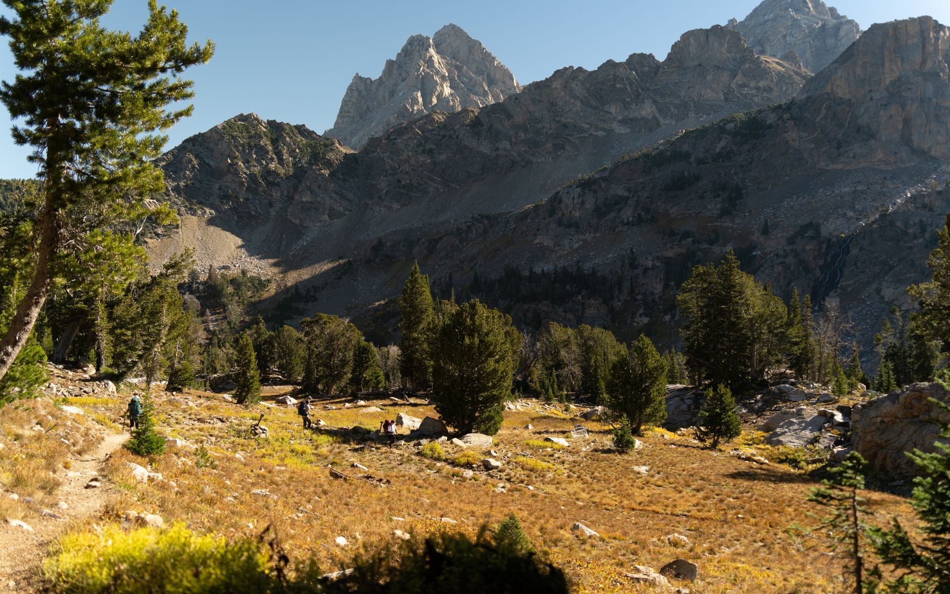
Lupine Meadows to Surprise and Amphitheater Lakes
Distance: 10 miles round-trip. Elevation gain: 3,000 feet. Difficulty: Strenuous. Season: Mid-June through October. This is one of the steepest maintained day hikes in the park. The Lupine Meadows trailhead starts at 6,732 feet, a few miles south of Jenny Lake off the inner Teton Park Road. The switchbacks grind through open avalanche slopes before the trail enters the subalpine zone. Surprise Lake sits at 9,700 feet and Amphitheater Lake at 9,698 feet, barely 10 minutes apart near the top. The view back across Jackson Hole toward the Gros Ventre Range opens dramatically on the upper switchbacks, and both lakes sit below the Cathedral Group wall with nothing between you and the granite. Budget six to eight hours. Wind picks up fast at these exposed ledges, so carry an extra layer even in mid-July. If you want company on your first time at this elevation, Jackson Hole EcoTour Adventures runs guided nature hikes in the Teton area and can pair trail time with wildlife and plant identification from a naturalist who knows the terrain.
Observation Point, Yellowstone National Park
Distance: 4.8 miles round-trip. Elevation gain: 400 feet. Difficulty: Moderate. Season: Late May through October. Start at the Biscuit Basin parking area on the main park road between Madison Junction and Old Faithful, about 2 miles north of the Old Faithful complex. The trail crosses the Firehole River on a footbridge and climbs the hillside above the Upper Geyser Basin to a ridgeline at 7,400 feet. From there you look straight down at Old Faithful, Grand Geyser, Castle Geyser, and the river bend below, at the exact moment hundreds of visitors are pressed against the boardwalk railings for a ground-level eruption view. Old Faithful erupts roughly every 90 minutes; visitor center staff post interval predictions throughout the day, so you can time your arrival at the overlook around an eruption window. A short detour through Solitary Geyser adds a quarter mile on the descent. This is consistently one of the most underrated viewpoints in the park.
Cirque of the Towers, Wind River Range
Distance: 26 miles round-trip. Elevation gain: 1,500 feet to the cirque floor. Difficulty: Strenuous, backpacking. Season: Late July through early September. The Wind River Range holds more than 40 peaks above 13,000 feet, and the Cirque of the Towers is its most dramatic basin. The standard approach starts from the Big Sandy Lodge Trailhead, reached by driving south from Pinedale on Wyoming Highway 353 for 35 miles of dirt road. A high-clearance vehicle is strongly recommended; passenger cars get through in dry conditions but the road has rutted sections. Most hikers camp at Big Sandy Lake the first night, then continue 4 miles the next morning to the cirque where Pingora Peak (11,884 feet), War Bonnet, and Shark's Nose form a granite theater. No permit is required for overnight travel in this section of Bridger Wilderness, which keeps the logistics simple. Campfire restrictions typically apply July through August, and water from snowmelt streams runs plentiful through mid-July. Carry a filter regardless. Peak season is late July through early September when the high passes are reliably clear of snow.
Popo Agie Falls, Sinks Canyon State Park
Distance: 2 miles round-trip. Elevation gain: 450 feet. Difficulty: Easy to moderate. Season: May through October. Sinks Canyon State Park lies 6 miles south of Lander on Wyoming 131. The canyon gets its name from the "sink," where the Middle Fork Popo Agie River drops into a limestone cavern and vanishes underground, resurfacing half a mile downstream as the "rise." The falls trail starts at the rise parking area and climbs through ponderosa pine to a multi-tiered waterfall tucked in a narrow canyon. It's short enough to finish before lunch and works for most fitness levels. Bighorn sheep appear regularly on the canyon walls May through October; morning is the most reliable time to spot them. The Sinks Canyon State Park visitor center has solid exhibits on the local limestone geology and the unusual hydrology of the sink and rise, worth 20 minutes before you hit the trail. Lander is a low-key, useful base for this hike and for Wind River approaches generally, and it earns a place on the list of best small towns in Wyoming for good reason.
Devils Tower Base Loop, Devils Tower National Monument
Distance: 1.3 miles, loop. Elevation gain: negligible. Difficulty: Easy. Season: Year-round (traction devices needed in winter). America's first national monument, declared in 1906, is an 867-foot phonolite porphyry column rising from pine and river country in the northeast corner of Wyoming, about 25 minutes from Sundance on Wyoming 24. The paved base loop circles the entire tower at close range, passing through boulder fields and pine stands with clear sightlines up the column. In June and July, climbers work the classic crack routes on the northeast and south faces, visible from the trail without binoculars. The entrance fee runs about $25 per vehicle (estimate). Allow 45 minutes at a comfortable pace; the rocky terrain near the base requires footwear with grip. The visitor center covers both the volcanic geology and the monument's cultural significance to more than 20 Northern Plains tribes, and it's open daily May through September.
Summer weekends draw a steady mix of climbers, families, and road-trippers who stop between the Black Hills and Yellowstone. If you go on a weekday morning in late June, the trail is significantly quieter and the light on the tower faces is better for photography before noon.
Lake Solitude, Grand Teton National Park
Distance: 14 miles round-trip from Jenny Lake west dock. Elevation gain: 2,600 feet. Difficulty: Strenuous. Season: July through mid-September. Lake Solitude at 9,024 feet is the natural extension of the Cascade Canyon day hike, continuing north from the canyon fork for another 4.5 miles as the trail climbs through thinning subalpine forest to an open basin below the Paintbrush Divide. The final approach is the steepest part of the whole route. The lake sits directly below the North Fork drainage with the Teton crest overhead. As a day hike it's a 10 to 11 hour commitment from the boat dock, which makes an early boat crossing (first boat runs around 7 a.m. in summer) essential. Overnight camping at the lake requires a Grand Teton backcountry permit, available for advance reservation through Recreation.gov starting in January, or in person at Colter Bay and Jenny Lake visitor centers. If you're planning to stay in the area before or after this hike, our Hotels and Lodges directory covers properties in Jackson and Teton Village within 20 minutes of the trailhead.
Vedauwoo Trails, Medicine Bow-Routt National Forest
Distance: 1 to 5 miles depending on route. Elevation: 8,000 feet. Difficulty: Easy to moderate. Season: May through October, with some routes accessible in winter. Vedauwoo (pronounced "Vee-da-voo") sits on I-80 about 30 minutes east of Laramie, where the highway cuts through a field of Sherman granite domes and boulders unlike anything else in southeast Wyoming. The coarse rock surfaces and boulder-field approach trails make this a popular spot for hikers who want to move off the smooth path without roping up. Loop trails from the main campground pass scrambling terrain and short technical spots that most fit adults can navigate with care. Summer afternoon thunderstorms build fast over the rocks; plan to be off exposed terrain by early afternoon. Curt Gowdy State Park, another 20 minutes west toward Cheyenne on Wyoming 210, adds reservoir-edge trails and creek-side walking for a quieter complement on the same day trip. Both work as backup options when afternoon storms shut down high-country routes or when you have half a day between Laramie and Cheyenne.
Quick Comparison
| Trail | Region | Distance (RT) | Gain | Difficulty | Open |
|---|---|---|---|---|---|
| Cascade Canyon | Grand Teton NP | 9 mi | 1,000 ft | Moderate | June–Oct |
| Lupine Meadows to Amphitheater Lake | Grand Teton NP | 10 mi | 3,000 ft | Strenuous | Mid-June–Oct |
| Observation Point | Yellowstone NP | 4.8 mi | 400 ft | Moderate | Late May–Oct |
| Cirque of the Towers | Wind River Range | 26 mi | 1,500 ft | Strenuous | Late July–Sept |
| Popo Agie Falls | Sinks Canyon, Lander | 2 mi | 450 ft | Easy–Moderate | May–Oct |
| Devils Tower Base Loop | Devils Tower NM | 1.3 mi | Minimal | Easy | Year-round |
| Lake Solitude | Grand Teton NP | 14 mi | 2,600 ft | Strenuous | July–mid-Sept |
| Vedauwoo Trails | Medicine Bow NF, Laramie | 1–5 mi | Varies | Easy–Moderate | May–Oct |
Frequently asked questions
Do you need a permit to hike in Wyoming national parks?
Day hiking in Yellowstone and Grand Teton does not require a separate permit beyond the standard park entrance fee (about $35 per vehicle for a 7-day pass, estimate as of 2025). Overnight camping in Grand Teton's backcountry does require a backcountry permit, which you can reserve in advance through Recreation.gov starting in January, or pick up in person at Colter Bay and Jenny Lake visitor centers. The Wind River Range falls within Bridger-Teton National Forest and does not require a permit for overnight travel in most zones, including the approach to Cirque of the Towers.
When is the best time to hike in Wyoming?
July through mid-September is the most reliable window for high-country hikes. Trails above 9,000 feet in the Tetons and Wind Rivers carry snow well into June most years. Yellowstone's lower-elevation boardwalk trails open earlier, often in late May, while routes above 8,000 feet follow in late May or early June depending on snowpack. September is worth considering: lighter crowds than August, the Teton Park Road still open, and the elk rut running across the valley. By mid-October most high-country routes are getting their first hard freeze.
How do you stay safe from bears on Wyoming trails?
Carry bear spray in the northwest quadrant of the state: Yellowstone, Grand Teton, the Wind River Range, and the Bighorns all have grizzly and black bear populations. Keep it in a hip holster, accessible without digging in your pack. Make noise on blind corners, particularly in dense vegetation. Keep 100 yards between you and bears and wolves, and 25 yards from bison and elk. Do not leave food or scented items in your tent; use bear canisters or hang food at designated sites. Morning and evening are peak bear activity times on most trails.
Which Wyoming hike is best for families with young kids?
The Devils Tower Base Loop (1.3 miles, paved, mostly flat) and Popo Agie Falls at Sinks Canyon State Park (2 miles, manageable grade) both work well with younger hikers. In Grand Teton, the String Lake Loop covers 3.7 miles on relatively flat terrain near the water and doesn't require the Jenny Lake boat fee. The Observation Point trail in Yellowstone is a good family option too, though the 400-foot climb takes more effort than a boardwalk walk and the round-trip of nearly 5 miles should be sized up against your group's pace.